March 25, 2024

Sols 4134-4135: Sun Blob Blues

Written by Natalie Moore, Mission Operations Specialist at Malin Space Science Systems
This image of the road behind was taken by Right Navigation Camera onboard NASA's Mars rover Curiosity on Sol 4132. Credits: NASA/JPL-Caltech.

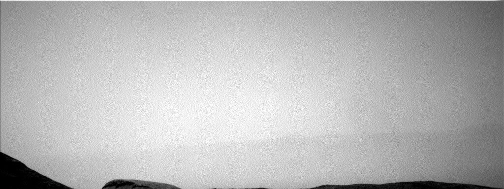
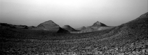
This image showing the road behind was taken by Right Navigation Camera onboard NASA's Mars rover Curiosity on Sol 4132. Credits: NASA/JPL-Caltech. Download image ›

Earth planning date: Friday, March 22, 2024

Sometimes it feels like we all make up the same brain and planning goes smooth as silk. Today I'm thankful it felt like that, because Friday plans have a higher potential to get rough. It really helps when the morning downlink brings down more data than expected and shows our drive completing successfully! The only thing getting us down was the “sun blob,” a 13 degree cone around the sun that ChemCam is not allowed to point within. If ChemCam is pointed at the sun while not in a safe focus setting, its optics or RMI detector could be damaged. The sun blob includes the sun’s entire daily path through the sky plus 13 degrees, in the event ChemCam gets stuck pointed somewhere and Earth is unable to respond in time. Unfortunately, the ChemCam RMI areas of interest these days are mostly all inside the sun blob, and it’s slowly moving southwards just like us! So while on Wednesday our rover was singing Back to the uGVr, today she’s singing the “Sun Blob Blues” by the Channel Surfers (not a real band). Some of the team even thinks the blob itself might be sentient and hunting us (not really).

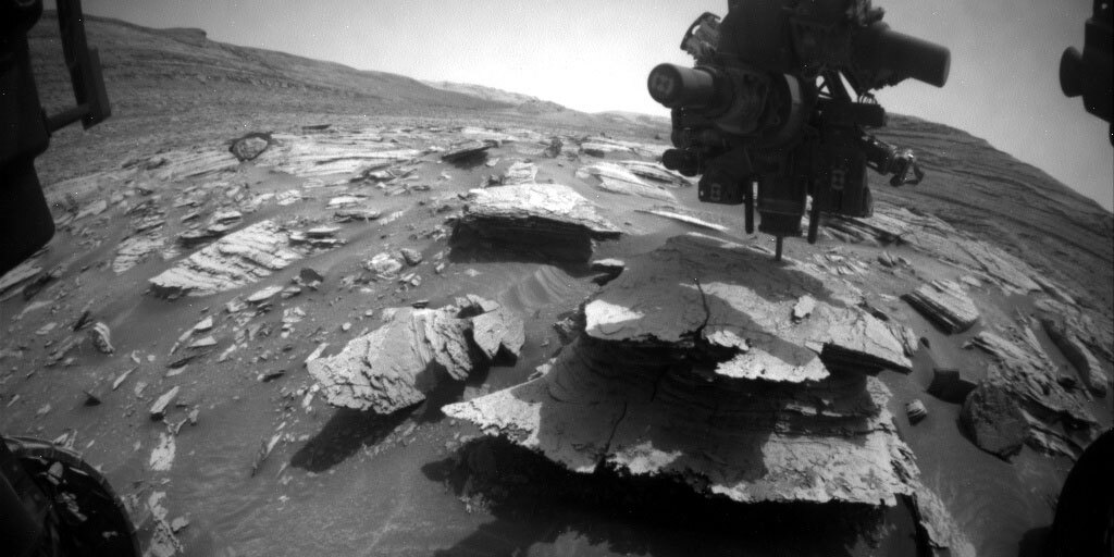
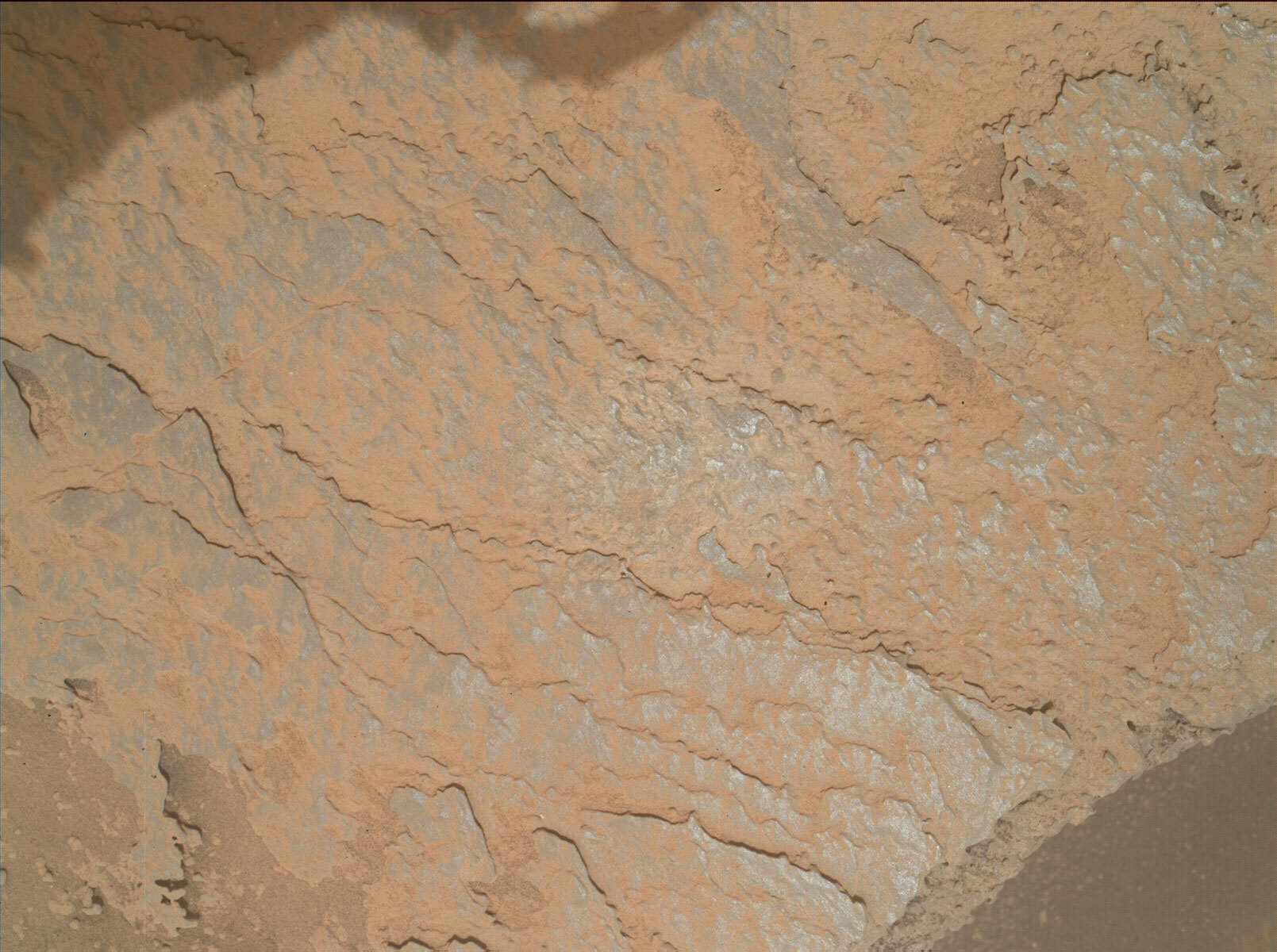
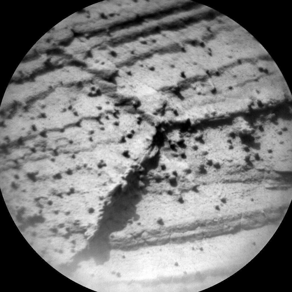
The first sol of this plan includes a ChemCam RMI of the beautiful Fascination Turret uGVr (upper Gediz Vallis ridge) outcrop that isn’t in the sun blob, 5 laser shots and a Mastcam documentation image of a bedrock target in our workspace named “Petite Capucin,” and a 12-frame Mastcam stereo mosaic of some gnarled-looking bedrock in front of us named “Sentinel Dome.” We also have full arm backbones with three contact science targets named “Thompson Canyon,” “Cabin Lake,” and “Smoky Jack” for MAHLI and APXS.

The second sol of this plan includes some highly-desired Mastcam imaging in the early morning of Fascination Turret and the rest of the uGVr from this location, which we’re hoping will illuminate some of the self-shadows inherent in the outcrop faces. ChemCam will acquire another RMI of Fascination Turret outside the sun blob and shoot another workspace target named “Phlox.” Then, we drive onward! Hopefully on Monday we will be ~23 meters further south and continue our imaging spree of this gorgeous area.

March 21, 2024

Sols 4132-4133: Back to the u.G.V.R.

Written by Sharon Wilson Purdy, Planetary Geologist at Smithsonian National Air and Space Museum
This image was taken by Left Navigation Camera onboard NASA's Mars rover Curiosity on Sol 4130.

This image was taken by Left Navigation Camera onboard NASA's Mars rover Curiosity on Sol 4130. Credits: NASA/JPL-Caltech. Download image ›

If the Curiosity rover had a song stuck in her head today, she might be humming “Back to the uGVR,” to the tune of The Beatles “Back in the U.S.S.R,” as she drives south along the eastern edge of the upper Gediz Vallis Ridge (uGVR). The rover drove up to the uGVR last summer and investigated several rocks; now with the beautiful “Fascination Turret” section of the uGVR in sight, the team is very excited to have another opportunity to further characterize the material within the ridge and assess the nature of its contact with the underlying Mt. Sharp bedrock.

The rover’s excellent power situation for this two-sol plan yielded the ability to do a wide range of activities. In the workspace in front of us, we used MAHLI to image a vertical banded rock with veins at “Col de Doodad.” We used the dust removal tool (DRT) and MAHLI to characterize the grain size and material in a flat bedrock target named “Three Tooth Doodad.” ChemCam LIBS will analyze a laminated ridge within bedrock at the “Kuna Crest” target with Mastcam providing a complementary context image. Mastcam planned stereo mosaics within the workspace to document small-scale laminations and to investigate the nature of subtle variations between light and dark bedrock at the “East Vidette” target. The “Giant Forest” Mastcam mosaic was scheduled to document interesting fractures in the nearby bedrock.

Looking off in the distance, the plan includes several observations of the Fascination Turret section of the uGVR so we can view it from different angles as we drive along our upcoming route. ChemCam was able to fit two long distance RMI images into the plan that document interesting ledges within Fascination Turret, while Mastcam put together a mosaic of the lower portion of the ridge to evaluate the composition, structure, and its relationship with the underlying bedrock.

Our plan incorporates several ENV activities including a dust devil survey, a suprahorizon movie, and a sky survey. Keep on humming along, Curiosity!

March 18, 2024

Sols 4130-4131: A Return to Your Regularly Scheduled Touch-And-Go

Written by Alex Innanen, Atmospheric Scientist at York University
Looking north towards the crater rim. This image was taken by Left Navigation Camera onboard NASA's Mars rover Curiosity on Sol 4128.

Looking north towards the crater rim. This image was taken by Left Navigation Camera onboard NASA's Mars rover Curiosity on Sol 4128 (2024-03-17 15:03:15 UTC). Credits: NASA/JPL-Caltech. Download image ›

Earth planning date: Monday, March 18, 2024

It was a fairly calm planning day after a few weeks of activity at Mineral King, with a familiar touch-and-go plan. That's not the only thing that's back to normal – ENV has ended our dust storm watch as dust activity has calmed down to seasonal levels. We even have a (slightly hazy) view of the crater rim again (see above)!

After leaving Mineral King behind we were greeted by a new workspace for the first time in almost 30 sols. For the "touch" part of the touch-and-go, APXS and MAHLI will be getting up close with bedrock target "Tunnel View." MAHLI will also be examining "Cardinal Mountain," a set of dark veins in another block.

While not getting quite as close as MAHLI and APXS, Mastcam and ChemCam are also taking advantage of the workspace with LIBS on "Ireland Lake" (appropriately named for the day after St Patrick's Day!), a ChemCam mosaic of "Fascination Turret," and Mastcam mosaics of the upper Gediz Vallis Ridge and "Koontz Pinnacle." On the ENV side, we're rounding out the sol with an image of the rover deck to track any potential movement from wind, and a couple of observations to monitor the decreasing dust. Then it's time to go – off towards Fascination Turret.

On our second sol, after the drive, we have our regular untargeted science block that will be given over to a ChemCam AEGIS activity, another deck monitoring observation, a line of sight to the crater rim, and a dust devil movie. After that Curiosity gets to take a well deserved nap for the rest of the plan.

March 18, 2024

Sols 4127-4130: Backstage: Quick Change!

Written by Emma Harris, Graduate Student at Natural History Museum
This image was taken by Front Hazard Avoidance Camera (Front Hazcam) onboard NASA's Mars rover Curiosity on Sol 4125. Credits: NASA/JPL-Caltech. Download image ›

This image was taken by Front Hazard Avoidance Camera (Front Hazcam) onboard NASA's Mars rover Curiosity on Sol 4125. Credits: NASA/JPL-Caltech. Download image ›

Earth planning date: Friday, March 15, 2024

Just prior to planning we found out the drilling attempt on Mineral King 3 unfortunately didn’t reach a depth suitable to collect samples for analysis. So, in a manner very similar to a quick-change backstage at the theatre, we altered our plan of action just minutes prior to planning. Instead of sending the drilled sample for analysis like we were able to do for Mineral King, Curiosity is driving away. Our incredible rover planners had already figured out where the rover was going to drive next, so it was down to the science team to figure out how to merge the science observations into the new plan.

On the first 2 sols of this plan, prior to driving away, APXS will take measurements on the shallow drill attempt at ‘Mineral King 3,’ as there are some drill tailings present. ChemCam has packed the plan with activities including the final LIBS observations in this workspace on some nodular rocks of interest ‘Wishorn Reservoir’ and ‘Diamond Mesa.’ ChemCam will then take an RMI mosaic of a sand trough named ‘Centre Basin’ near the rover, as well as two long distance RMI mosaics of ‘Texoli,’ and ‘Dragtooth’ buttes. Mastcam will take the standard documentation images on the ChemCam LIBS observations, as well as a final change detection image of ‘Florence Peak,’ a sand ripple in the workspace we have been monitoring for a few weeks to see how much it moves over time. Mastcam also have some larger mosaics planned including extensions of previously imaged areas including the drilling location ‘Mineral King,’ as well as targets ‘Consultation Lake’ and ‘Cottonwood Pass.’ During this plan we also have a range of environmental monitoring activities: Mastcam will be used for a sky survey, and Navcam will be searching for dust devils and will be used to take a suprahorizon movie.

Curiosity will then drive closer to ‘Fascination Turret,’ part of the Gediz Vallis Ridge to inspect an area of geologic interest to the team. When the rover arrives at our new workspace, it will take a Navcam mosaic, and a MAHLI image of the wheels. We then instruct the rover to automatically pick a ChemCam LIBS target to make the most of the science time and give us some preliminary data to analyse when we come into planning on Monday. These types of planning days, although often hectic, show the power of pre-planning and highlight all the work that happens backstage on this efficient rover team.

March 14, 2024

Sols 4125-4126: Woohoo! We're 'Go' for Drilling At 'Mineral King 3!'

Written by Abigail Fraeman, Planetary Geologist at NASA's Jet Propulsion Laboratory
Image of the “Mineral King 3” location

NASA's Mars rover Curiosity acquired this image of the "Mineral King 3" location using its Mars Hand Lens Imager (MAHLI), located on the turret at the end of the rover's robotic arm, on March 12, 2024, Sol 4123. Download image ›

Earth planning date: Wednesday, March 13, 2024

The title of the blog gives away the big news of today - we are “go” to plan drilling at Mineral King 3. Yay!

For those not following along every day, here’s a quick recap of how we got to drill target #3 on this block: We drilled the original “Mineral King” target on sol 4107, but the drill did not reach as deep into the rock as it usually does, so we didn’t know how much powdered sample we’d collected for analysis. We learned the answer was we had enough sample for CheMin analysis, but not for SAM. We decided to try to drill again to collect more sample, so we picked a spot named “Mineral King 2” on the same block. Alas! After we attempted to preload the drill, we found out that the Mineral King 2 spot would not be a good location to try to drill. So, on Monday, we picked another location, now up to Mineral King 3, and tried the drill preload again. We found out this morning that our preload data are looking good, so we are “go” to plan for a full drill of Mineral King 3 in today’s plan!

The drilling and subsequent characterization of the drilled material are the stars of the first and second sols of today’s plan, respectively. We do have a little bit of time for remote sensing around these activities, so we’ll collect a ChemCam LIBS observation of a target named “Long Lake,” a ChemCam RMI observation, and several Mastcam mosaics to complement the Mastcam coverage we already have in the area. We’ll also be monitoring the environment with observations to look at the dust in the atmosphere, measure radiation at the surface, and look for changes in the sand on the ground below us. Finally, we will also image the workspace to look for one big, rover-made change. I really hope we’ll be greeted with the image of a fresh drill hole on Friday morning (which would come with fresh donut holes delivered to the tactical team).

March 12, 2024

Sols 4120-4122: Mars Throws Us a Curveball!

Written by Lucy Thompson, Planetary Geologist at University of New Brunswick
This image was taken by Chemistry & Camera (ChemCam) onboard NASA's Mars rover Curiosity on Sol 4119.

RMI of the “Roaring River” LIBS target, analyzed on Sol 4119. This target is on the same block as the “Vernal Falls” and “Unicorn Peak” targets included in today’s plan. This image was taken by Chemistry & Camera (ChemCam) onboard NASA's Mars rover Curiosity on Sol 4119. Credits: NASA/JPL-Caltech/LANL. Download image ›

Earth planning date: Friday, March 8, 2024

As we previously documented, the first “Mineral King” drill hole did not quite reach the target depth that we typically desire to ensure that we have enough sample in the drill stem to deliver to our internal CheMin and SAM instruments. While we did get a successful X-ray diffraction CheMin analysis, we did not quite have enough sample left for SAM to be able to complete their Evolved Gas Analysis (EGA). The rover engineers selected a new potential drill spot on the same block, and this morning we got the results of the APXS, MAHLI and preload test (to check for stability and drillability) on that spot. While the chemistry and imaging indicated that it was a good candidate the preload test did not pass. The selected target was just a little too close to the rover. As the APXS strategic planner today, I reported the results of the APXS chemical analysis to the team; we were looking for the “Mineral King2” area to have a similar composition to the first drill target. We found out about the failure of the preload test as we were ready to deliver our preliminary plan, but we are all used to reacting to the surprises that Mars occasionally sends our way! The science, engineering and uplink teams did an excellent job responding to the sudden change of plans and we managed to come up with a homerun, version 2 of our plan to accommodate the late-breaking news, taking advantage of the extra power and time available to us, given that we were not proceeding with drilling!

The geologists planned ChemCam LIBS on two targets, “Vernal Falls” and “Unicorn Peak,” which will also be documented with Mastcam. The two targets are on a nearby polygonally fractured block, the same block as the previous “Roaring River” target. ChemCam will also utilize its remote imaging capabilities to continue looking at the layering in the “Texoli” butte and the chaotic structure within the nearby Gediz Vallis deposit (see my previous blog for rationale). We are taking advantage of the unexpected bonus time and power to cross a few Mastcam liens off our list. Mastcam will extend imaging in and around the “Cottonwood Pass” and “Mount Carillon” areas to provide more context to the Mineral King drill site and surrounding area. We are also acquiring a MARDI image to monitor how the wind might be moving sand and dust around as we remain parked at this location.

All that extra power and time meant that the environmental scientists were able to plan a glutton of observations, especially useful right now as Curiosity is in a dust storm watch scenario, as dust activity increases on Mars. Environmental Navcam observations include line of sight observations, two dust movies, two 360° sky surveys, as well as zenith and suprahorizon movies. We are also acquiring Mastcam tau and sky column observations, as well as planning coordinated ChemCam passive sky and APXS atmospheric activities. The plan is not complete without the standard REMS, DAN and RAD activities.

The rover engineers have found another viable spot on the same block as “Mineral King,” a bit further from the rover, so we will probably try our triage drill activities on the new target when we resume planning next week. We are all hoping for a more successful outcome than for Mineral King2.

March 12, 2024

Sols 4123-4124: Third Time's the Charm!

Written by Remington Free, Operations Systems Engineer at NASA's Jet Propulsion Laboratory
This image was taken by Right Navigation Camera onboard NASA's Mars rover Curiosity on Sol 4121.

This image was taken by Right Navigation Camera onboard NASA's Mars rover Curiosity on Sol 4121. Credits: NASA/JPL-Caltech. Download image ›

Earth planning date: Monday, March 11, 2024

Robotic arm downlink chair here! Rather than planning for the next day, I am on the team which assesses data that comes back from the rover and determines the health and safety of its hardware. I was responsible for assessing our last preload checkout on our second “Mineral King” target last Friday. Unfortunately, we were not confident enough in the initial data we were reading in the target to feel comfortable moving towards a full drill. In our feed extended configuration without utilizing stabilizers, we have to be pickier about the drilling attempts we make to protect our hardware. We wouldn’t want to get our drill stuck in a rock!

Today, we are planning for another checkout on our third “Mineral King” target on Sol 4123. We’re really excited about the potential science value from this area, so we are willing to try again to get more sample. Recall that for our first “Mineral King” target, while we were able to successfully drill, we did not get our normal amount of powder sample to do all of the science analysis we wanted to, hence the additional drilling. We’ll be able to assess on Wednesday whether our third checkout passes our engineering criteria to proceed with a full drill. In addition to the preload checkout, we have a Sol 4123 environmental science block with Navcam measurements to determine scatterings of atmospheric aerosols, take a cloud movie, and search for dust devils. We will also take Mastcam measurements to measure optical depth.

On Sol 4124, we will not have any arm activities while we wait for our engineers to assess the target checkout, and will focus on more science measurements. In our first science block, we have planned ChemCam measurements to document bedrock geochemistry, take spectroscopic measurements of our drill tailings from the first Mineral King drill target, and take long distance imaging of “Fascination Turret,” a nearby ridge of interest. We also have planned Mastcam and Navcam activities to measure optical depth, document ChemCam targets, and collect stereo documentation of a nearby outcrop rock. Later on the same sol, we will take additional Mastcam imaging of our “Florence Peak” target which we have been observing for a number of sols. We are interested in how our measurements are changing over time. We will also be taking additional Navcam measurements as we continue monitoring atmospheric aerosols and atmospheric opacity in the current dusty environment.

We’re excited to get our engineering data back from our third “Mineral King” target to see if we can do another drill!

March 6, 2024

Sols 4118-4119: Can I Have a Second Serving, Please? Oh, Me, Too!

Written by Susanne Schwenzer, Planetary Geologist at The Open University
ChemCam remote imager picture that shows some of the laser spots on the target 'Roaring River.'

ChemCam remote imager picture that shows some of the laser spots on the target “Roaring River.” This image was taken by Chemistry & Camera (ChemCam) onboard NASA's Mars rover Curiosity on Sol 4117 (2024-03-06 04:57:48 UTC). Download image ›

Earth planning date: Wednesday, March 6, 2024

Imagine you are sitting at a dining table with a few friends, and you had a small portion of delicious food, but you want some more. And instead of just helping yourself, you have to ask a friend to get it for you, but before they can do so, you’ll need to ask everyone around the table if you actually may bother your friend to do so… That’s about how the SAM team must have felt today, but it’s also not the first time they had to do it, so they knew how to ask, and of course are getting their second helping. What that means is that Curiosity is going to drill at the Mineral King site again, because the results we have so far indicate that we need to collect more sample for SAM analysis.

But that was not the only negotiation we had to do today… we also needed to accommodate a lot of interesting observations in just a tiny amount of time, which is of course impossible. The way we make these decisions is by asking: What can we do later, and what would not be the same if it had to wait? Those are interesting discussions, and they require the entire expertise of the team present. It turned out that most things can wait just a little longer, and one is looking for a change between two measurements, so, it’s even beneficial for this observation to wait a little longer. I was the Science Theme Lead for the Geology and Mineralogy planning group today, which is the role to help manage the decision making. Honestly, I am glad I am not new to the role as today felt a little bit like keeping kittens in the box (yes, you don’t always know where every single one is!). But with the excellent team on today (someone called us the ‘sporty people’), we managed to have everything lined up even before the allocated time for the Geo-planning! And here is what Curiosity will do:

With SAM’s request for more sample granted, the next two sols will be to prepare the second drill very near the Mineral King target, called “Mineral King2.” There will be the preload test – pushing on the rock with the drill bit to make sure it’s stable and doesn’t move or crack during drilling, and APXS and MAHLI on the potential new drill spot. That will take a lot of the energy available, and we’ll have very little left for other activities.

Nevertheless, ChemCam is also getting seconds, this time of a fractured target, to see if we can get more data of the fracture itself. It’s a tiny target and hard to hit, but we’ll try again and this way add to our data from Roaring River, called “Roaring River 2.” ChemCam is also adding to its long-distance imaging footage of the Texoli area. Other activities include dust devil movies and atmosphere opacity measurements, as we are in the dusty times of the martian year. DAN is measuring the water content in the ground, too, completing a full plan that makes optimal use of the resources we have available for these two sols. Let’s see how the seconds tasted when we get the data!

March 5, 2024

Sols 4116-4117: Rover Kinesthetics

Written by Scott VanBommel, Planetary Scientist at Washington University
This image was taken by Left Navigation Camera onboard NASA's Mars rover Curiosity on Sol 4113.

This image was taken by Left Navigation Camera onboard NASA's Mars rover Curiosity on Sol 4113. Credits: NASA/JPL-Caltech Download image ›

Earth planning date: Monday, March 4, 2024

It has been a busy and exciting week for Curiosity and its science team. Our intrepid rover successfully drilled its 40th sample on Mars and today followed it up with an intensive campaign to characterize the tailings expelled while drilling “Mineral King.” When APXS analyzes a target, it receives signals from the top millimeter or less of the sample (similar to ChemCam, depending on the number of laser pulses conducted). Drilled material extracted by Curiosity and fed to SAM and/or CheMin, however, is typically extracted from 2+ cm below the surface. Drill tailings therefore provide APXS (and ChemCam) a more representative sample of the material analyzed by CheMin and/or SAM than pre-drill analyses of the target surface. Given images acquired previously showed a visually heterogeneous tailings pile, the 4116-4117 plan focused in part on acquiring MAHLI images and APXS analyses of not one but two spots on Mineral King's tailings.

Other activities in the plan included ChemCam analyses and Mastcam imaging of the targets “Roaring River” and “Big Meadows” as well as further photometry experiments. Images were also acquired post-APXS of the tailings pile as well as of various rover components such as the drill bit and the CheMin inlet cover. Environmental monitoring activities rounded out the plan.

This summary of today's plan certainly does not do the rover nor science and engineering team any justice given the complexity of its execution. In order to acquire all the MAHLI images and APXS data in the plan, there were six distinct arm segments, referred to as “arm backbones.” All told, a pretty impressive display of kinesthetics by Mars’ eldest rover.

March 1, 2024

Sols 4114-4115: Bingo! It's Official – Curiosity's 40th Successful Drill Hole on Mars!

Written by Lucy Thompson, Planetary Geologist at University of New Brunswick
ChemCam RMI of the Mineral King drill hole

This image of the "Mineral King" drill hole was taken by Chemistry & Camera (ChemCam) onboard NASA's Mars rover Curiosity on Sol 4108. Credits: NASA/JPL-Caltech/LANL. Download image ›

Earth planning date: Friday, March 1, 2024

The "Mineral King" drill hole did not quite reach the target depth that we typically desire to ensure that we have enough sample in the drill stem to deliver to our internal CheMin and SAM instruments. However, based on the information we did have (see details in the Sol 4110 blog), we proceeded with delivery to CheMin, and got the good news yesterday that CheMin received enough sample to complete an X-ray diffraction analysis. We officially have our 40th successful drill hole! Based on the preliminary CheMin results, the SAM team are planning a power-hungry, Evolveded Gas Analysis (EGA) of the "Mineral King" sample. This will provide further information on the composition.

Despite the power restrictions, the geology and atmospheric science teams made good use of the remaining time and power available to plan a slew of observations in this 2-sol weekend plan. To complement the previous APXS and ChemCam analyses of the "Mineral King" target prior to drilling, and the CheMin and SAM analyses, ChemCam will fire its laser at the wall of the drill hole to look for chemical variations with depth. The resulting laser pits will be captured with a Mastcam image, which will also help us plan MAHLI and APXS deployments on the powdered sample surrounding the drill hole next week. ChemCam will also analyze the "Nameless Pyramid" target on the same block, another example of the dark rock that we drilled into. We are also acquiring additional Mastcam imaging to extend coverage around the "Mineral King" drill block.

We are not focusing all our activities in the vicinity of our drill hole though. ChemCam will also utilize its remote imaging capabilities to look at the layering in the "Texoli" butte and the chaotic structure within the nearby Gediz Vallis deposit. We have been imaging the Texoli butte from different vantage points along our traverse to better understand the nature of the layering and sedimentary structures that can help us interpret the geological history of this section of Mount Sharp. The Gediz Vallis deposit has also been of interest for some time now, and our current position, very close to a section of the ridge material, provides the perfect opportunity to try and understand the processes that formed this late-stage deposit.

A photometry experiment on the second sol will use Mastcam and Navcam images to view areas near the workspace. This is one of a number of such observations that are repeated at different times of day, with variable lighting conditions, while the rover is stationary here at the "Mineral King" drill site. The experiment helps us to gain a better understanding of the surface textures at small scales and their influence on the reflected sunlight.

Observations to monitor changes in atmospheric opacity and dust are also included. We are acquiring several Navcam observations (sky flats and line of sight observations, as well as dust devil, suprahorizon and zenith movies) and a Mastcam tau. The plan is not complete without the standard REMS, DAN and RAD activities.

We are looking forward to coming back next week, hopefully with the news that we had a successful SAM EGA analysis. Assuming success, we will empty the drill stem of any remaining sample, which then allows us to use the arm for contact science (MAHLI and APXS). I will be the APXS strategic planner next week, and I am eager to help plan the APXS observations of the powdered sample around the drill hole. These results will be used to further refine the CheMin and SAM determined mineralogy of "Mineral King."