February 29, 2024

Sols 4112-4113: In The Presence Of Royalty

Written by Emma Harris, Graduate Student at Natural History Museum
This image was taken by Mast Camera (Mastcam) onboard NASA's Mars rover Curiosity on Sol 4107.

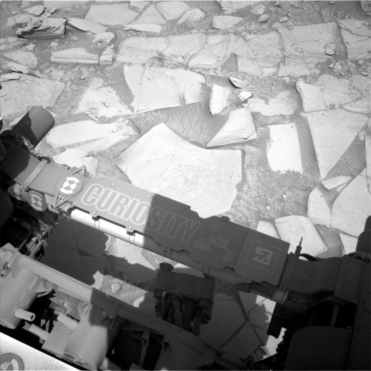
This image was taken by Mast Camera (Mastcam) onboard NASA's Mars rover Curiosity on Sol 4107. Credits: NASA/JPL-Caltech/MSSS. Download image ›

Earth planning date: Wednesday, February 28, 2024

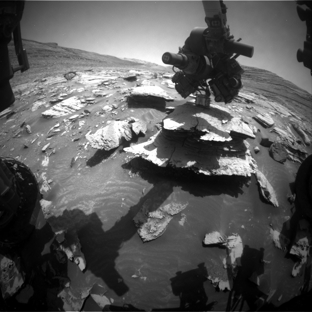
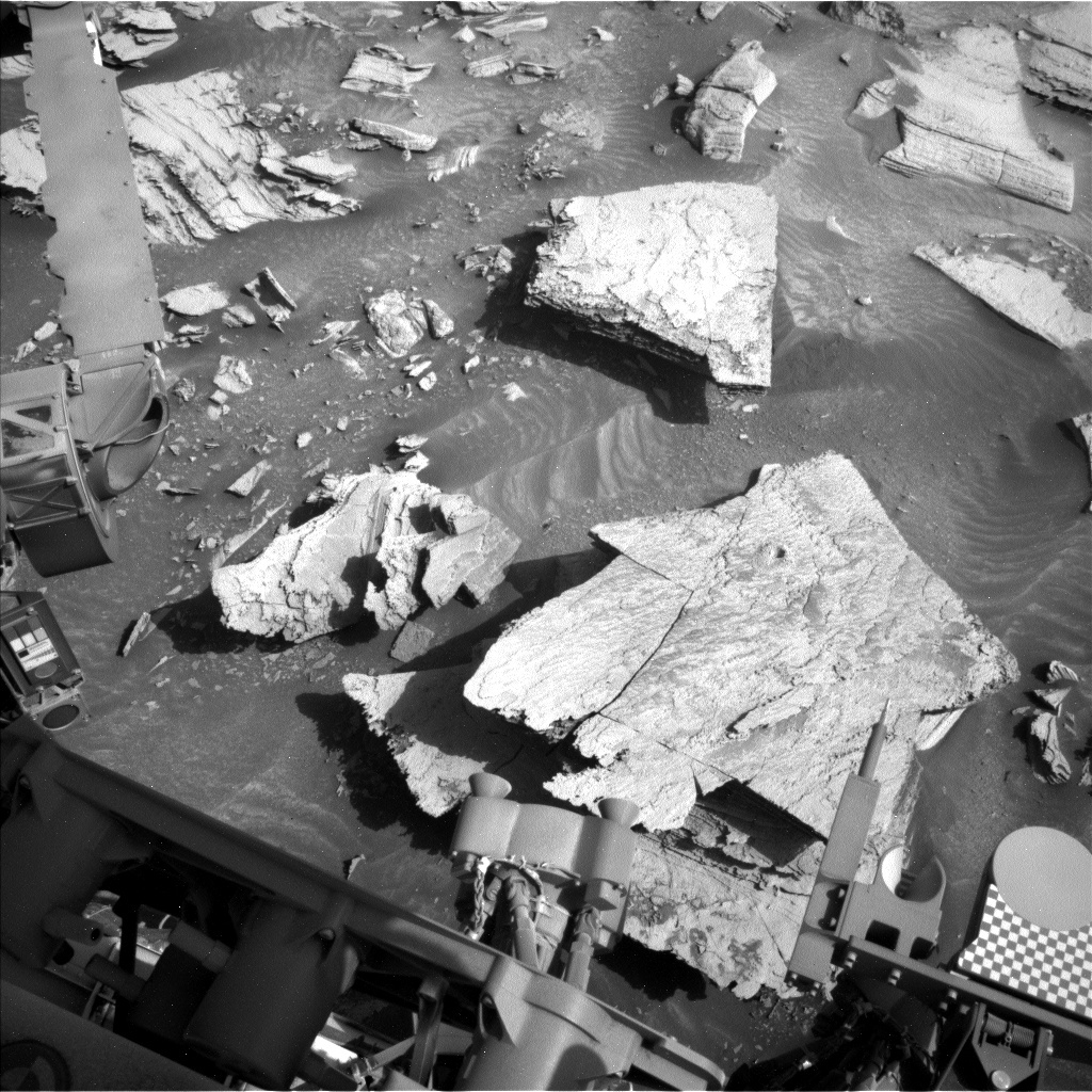
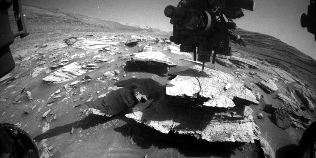
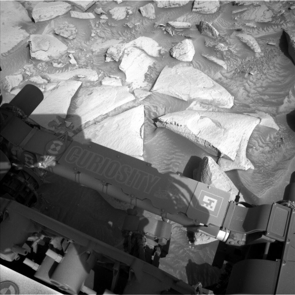
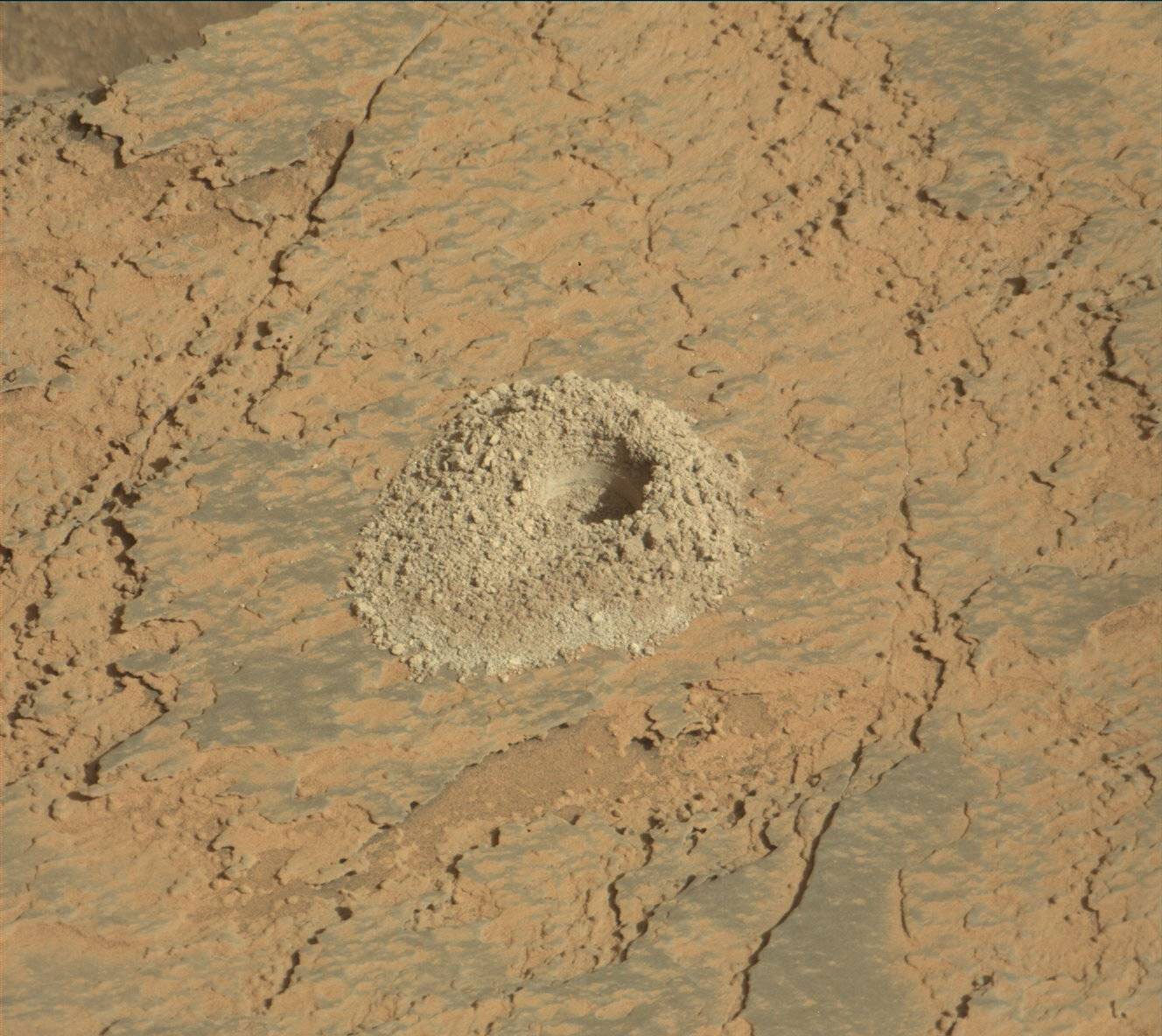
Over the weekend Curiosity successfully drilled into ‘Mineral King!’ The drilling stopped a little short of the target depth, however we think there was enough sample to be sent for analysis. ‘Mineral King’ has now been analyzed within the CheMin instrument, and we are awaiting the results. After we see those results tomorrow morning, we will make the decision if we also want to analyze the sample with the Sample Analysis at Mars – SAM – instrument. The first sol of this two sol plan contains the preconditioning of SAM to optimistically get us ready to deliver the sample to SAM on Friday and, during this time, Curiosity stays put next to the drill hole, awaiting the results of analysis. This leaves plenty of time to take in the beautiful views of our kingdom.

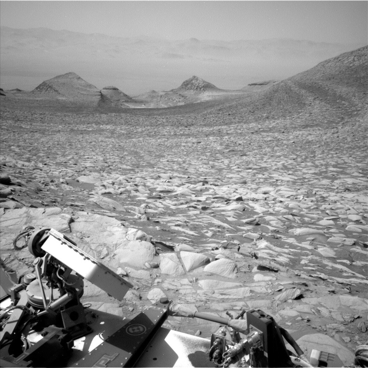
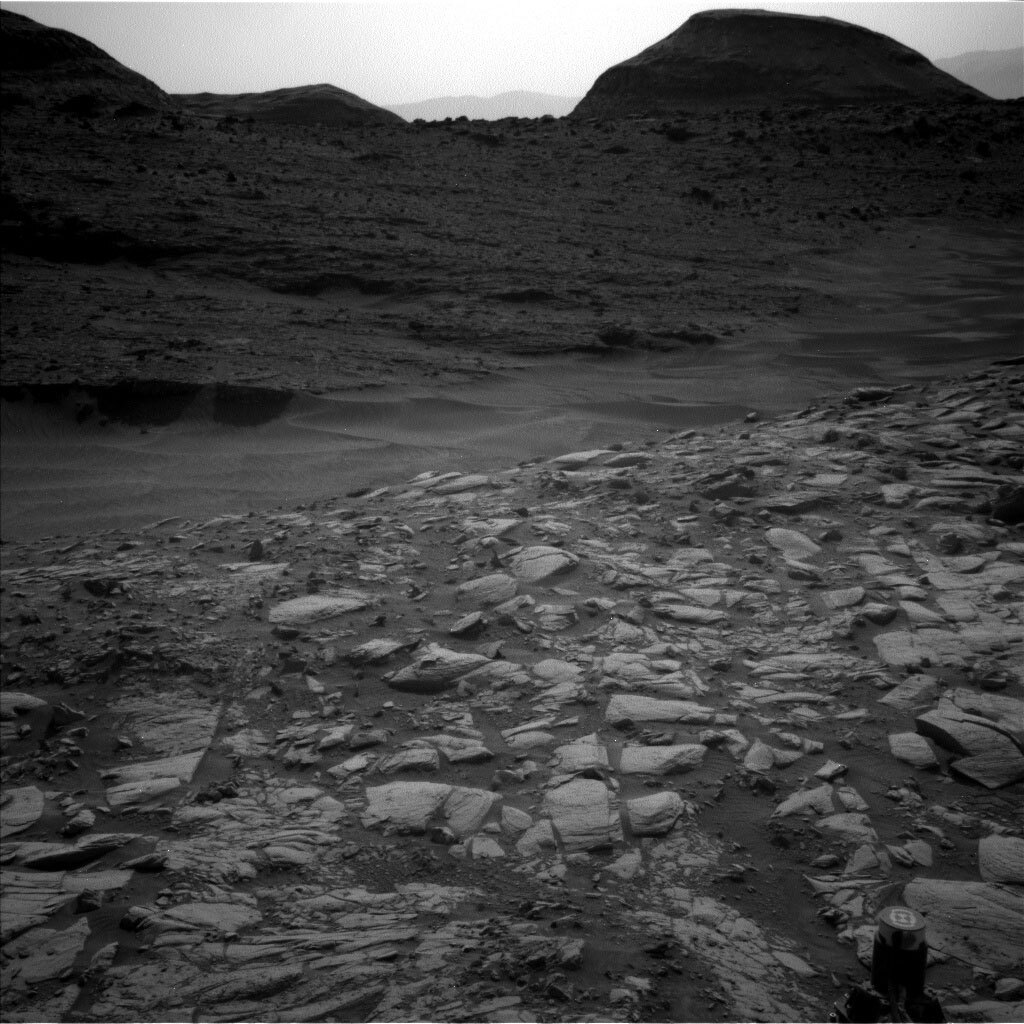
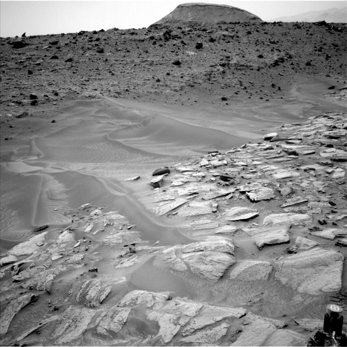
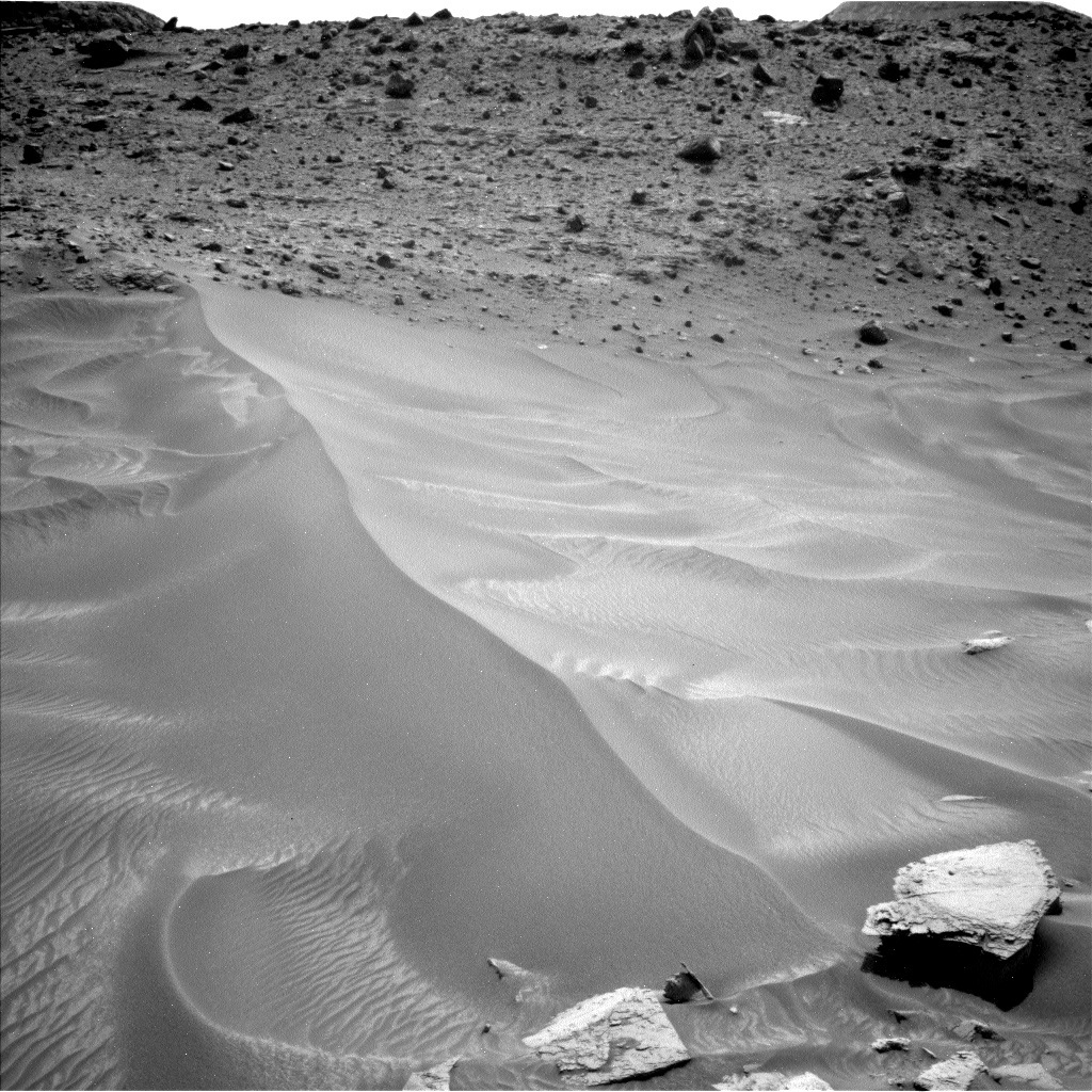
Today the science team planned a whole host of observations. Mastcam will continue to admire our noble drill hole by taking a single frame of ‘Mineral King’ for a MAHLI wind assessment, as well a single frame of some sandy ripples in the workspace called ‘Florence Peak’ as part of a change detection campaign. Mastcam will also look further afield taking a 9x2 mosaic of ‘Wilkerson butte’ to identify the sedimentary structures here and will then look back and take a 13x2 mosaic of an area we’ve previously driven by named ‘Consultation Lake’ to search for a particular fracture pattern that’s of interest to the science team. On the second sol, Mastcam and Navcam are kept busy with photometry observations.

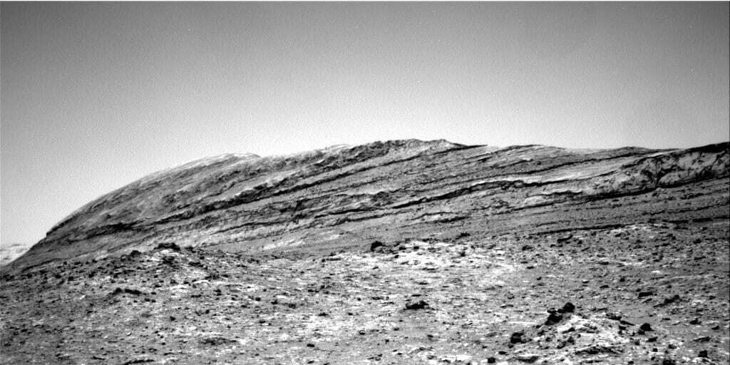
ChemCam has 2 LIBS targets in the plan. The target ‘Woods Lake’ is on the surface of a rock that looks similar to the drill hole Mineral King rock, with a second LIBS target ‘Lake Basin’ on an exposed layered surface of a nearby rock. The great thing about a drill campaign is we get the time to explore lots of rocks in Curiosity’s workspace! ChemCam is also targeting ‘Fascination Turret,’ part of the Gediz Vallis Ridge, with two long distance RMIs. Curiosity will spend more sols in the presence of royalty here at the ‘Mineral King’ drill hole as we continue with sample analysis and remote science observations throughout the week.

February 26, 2024

Sols 4107-4109: Drilling Mineral King

Written by Sharon Wilson Purdy, Planetary Geologist at Smithsonian National Air and Space Museum
This image was taken by Front Hazard Avoidance Camera (Front Hazcam) onboard NASA's Mars rover Curiosity on Sol 4105. Credits: NASA/JPL-Caltech. Download image ›

This image was taken by Front Hazard Avoidance Camera (Front Hazcam) onboard NASA's Mars rover Curiosity on Sol 4105. Credits: NASA/JPL-Caltech. Download image ›

Earth planning date: Friday, February 23, 2024

The Curiosity rover remained parked on the Mt. Sharp bedrock with a beautiful view of the upper Gediz Vallis ridge as we embarked on a busy and exciting 3-sol planning day. With preliminary data in hand used to understand the composition and texture of the gray "Mineral King" rock in front of us, we decided to proceed with drilling at this location!

ChemCam and Mastcam teamed up to document the composition and texture of several rocks in the workspace starting with the "Mineral King" target before the start of the drilling activity. ChemCam also scheduled a Z-stack observation (i.e., multiple images over a range of focus settings) to further characterize the pre-drill surface. The team also selected the "Lilley Pass" target to investigate the knobby bedrock beneath "Mineral King," and the nearby "Mather Pass" target to investigate a rock that appears similar in appearance and color to our selected drill target. Mastcam built two stereo mosaics for the weekend plan; one mosaic will document ground disturbances nearby, and the other will extend previous coverage of the "Mount Carillon" region to image the different types of cracks and breaks within the rocks.

Looking up and off into the distance, we have two ChemCam long distance RMI images in the weekend plan. One image will provide insight into the tantalizing rocks at the base of "Fascination Turret" in the upper Gediz Vallis ridge, and the other will get a glimpse behind us at landforms in the Marker Band Valley region. Rounding out these targeted activities is a ChemCam passive sky observation to survey the amount of water vapor in the atmosphere.

Good luck with the plan, Curiosity. Rest assured that you have lots of Earthlings who will be thinking of you over the weekend!

February 26, 2024

Sols 4110-4111: Mining Into Mineral King

Written by Ashley Stroupe, Mission Operations Engineer at NASA's Jet Propulsion Laboratory
This image was taken by Left Navigation Camera onboard NASA's Mars rover Curiosity on Sol 4107.

This image was taken by Left Navigation Camera onboard NASA's Mars rover Curiosity on Sol 4107. Credits: NASA/JPL-Caltech. Download image ›

Earth planning date: Monday, February 26, 2024

The planning team came in after the weekend to see another beautiful Martian drill hole on the target Mineral King! Mineral King is named after a silver mining district in Sequoia National Park, California. This was a pretty odd-looking rock, with the big overhanging ledges and several different colors, so we were all pretty anxious to see the drilling results. Fortunately, the rock was strong enough to drill without the rock layers breaking apart. However, it was also hard enough to slow down our drill progress and require percussion near the end. As a result, this hole is on the shallow side, meaning we may not have collected as much sample to analyze. However, we have had successful sample analyses after similarly shallow drill holes (like Edinburgh back on sol 2710) and our portion characterization does show we have sample, so the team is optimistic and going forward with dropping off sample to CheMin today. We prefer to do the sample drop-off as close as possible to when we’ll be doing the CheMin analysis, which is at night during cooler temperatures. While we are waiting for the sun to go down we are doing some targeted science and imaging.

This image was taken by Front Hazard Avoidance Camera (Front Hazcam) onboard NASA's Mars rover Curiosity on Sol 4107.
This image was taken by Front Hazard Avoidance Camera (Front Hazcam) onboard NASA's Mars rover Curiosity on Sol 4107. Credits: NASA/JPL-Caltech. Download image ›

First thing, ChemCam is taking a LIBS observation of the “Mount Sill” target, which is a dark-toned platy layer on the same rock as Mineral King. ChemCam is also taking both LIBS and passive observations on the Mineral King drill tailings and drill hole wall. Curiosity will then turn attention to the atmosphere, taking a Navcam line-of-site image of the atmospheric dust within the crater and a large dust devil survey. Before taking a nap, there is a Navcam image of the CheMin inlet prior to dropping off sample. After the nap, we wake up to do a high-temperature diagnostic with the M100 filter wheel, followed by a Mastcam solar tau and another Navcam line-of-sight image to look at dust in the atmosphere. After another nap, Curiosity wakes up in the evening to drop off some drill sample to CheMin. We are dropping off two sample “portions” to CheMin, which involves rotating the drill bit backwards for less than a second. Overnight, CheMin will analyze the sample and then dump it out. We should have results of the analysis by planning on Friday, when we will find out if Mineral King will live up to its name (though we probably won’t find any actual silver) and we’ll decide if we want to proceed to drop sample to SAM.

On the second sol of the plan, we read out the data from CheMin and do some more imaging and remote science. ChemCam takes a LIBS observation of the “South Guard” target, which is a gray-toned platy target also on the Mineral King rock, giving us the ability to compare the different colored areas. ChemCam also is taking a 40-frame RMI extension of the mosaic of Fascination Turret on the upper Gediz Vallis ridge. Mastcam then takes ChemCam follow-up images, one of South Guard and Mount Sill and an 18-frame mosaic of the upper Gediz Vallis ridge RMI target. Mastcam also takes a 48-frame extension of the mosaic on Texoli, which is a butte that shows eroded sedimentary structures, and an observation on the Marker Band following up on a ChemCam observation from the weekend. Finally, we take the post-drop-off Navcam image of the CheMin inlet and a dust devil movie. For the rest of the sol, Curiosity gets to rest and recharge in preparation for hopefully doing SAM activities in the rest of the week.

February 20, 2024

Sols 4104-4106: Dark Band Drill Surprise

Written by Natalie Moore, Mission Operations Specialist at Malin Space Science Systems
Navcam Left image of the road behind us from Sol 4096, depicting the light and dark rock layers we’ve been driving through.

Navcam Left image of the road behind us from Sol 4096, depicting the light and dark rock layers we’ve been driving through. Credits: NASA/JPL-Caltech. Download image ›

Earth planning date: Tuesday, February 20, 2024

No time for Monday brain on a Tuesday! Following a four-day US holiday weekend, our Mars plans take place on Tuesday and Friday this week. Since I am scheduled for Mastcam operations all week, this morning I ran my trusty script telling me how much Mastcam data were downlinked from the weekend. Immediately there was a mystery: Saturday’s data downlinked just fine but Sunday’s data wasn’t showing up. Missing data could have many causes, but the two most likely are: something happened with the rover, or something happened with the data transmission between Mars and Earth. Luckily it was quickly discovered to be the latter; our Payload Downlink Coordinator for today let us know that our morning downlink was halted because of Earth-weather conditions at the Deep Space Network station we tried to use. Despite not having the data right away, this is always good news because it means our commands all worked and the data is on its way to Earth. We were told the missing data would be available this afternoon at the earliest, so for planning we made do with the data we had.

We did get our Mastcam arm workspace images down from Sunday, though, and it showed a new location at a highly desired dark-toned rock layer. The weekend drive was successful! It was quickly determined our wheels were stable enough to unstow the arm and put weight on it (like for drilling), and since this is the nicest Gale crater terrain has been in a while the team quickly pivoted from driving away to staying here and trying to drill. This plan became our first of the “Mineral King” drill campaign.

We saved all the arm activities for the second sol, so we start sol 4104 with a remote science block including: ChemCam LIBS on “Mount Mallory,” Mastcam image of the LIBS attempt, and 20 Mastcam stereo frames of the terrain surrounding us. Navcam finishes off the block with some long dust devil and cloud movies, not only for science but also to make use of the battery charge while we can. The second sol is run by the arm activities: a 7-image MAHLI mosaic of the Mineral King block from an angle to show the thickness of the dark layers, DRT on Mineral King with a full-MAHLI-suite of images on the dust-free area, a pre-load test of the drill bit on Mineral King to test the strength of the rock (the stronger the rock, the less likely it’ll fracture or shift), and finally APXS integrations in the evening over the dust-free Mineral King to gather mineral composition pre-drilling. The third sol is mainly a battery recharge sol, but we’re still planning a ChemCam LIBS on “Mount Carillon,” a Mastcam mono mosaic of the LIBS attempt and surrounding context, and many Navcam dust devil movies. If the pre-load test on Mineral King goes well, we might be drilling this weekend!

February 16, 2024

Sols 4100-4103: Moving "Inland" From Gediz Vallis Channel

Written by Abigail Fraeman, Planetary Geologist at NASA's Jet Propulsion Laboratory
This image was taken by Left Navigation Camera onboard NASA's Mars rover Curiosity on Sol 4098.

This image was taken by Left Navigation Camera onboard NASA's Mars rover Curiosity on Sol 4098. Credits: NASA/JPL-Caltech. Download image ›

Earth planning date: Friday, February 16, 2024

In this weekend's plan, Curiosity will continue to support two sets of long-term science campaigns. First, we want to understand the processes that built Mt. Sharp's sulfate-bearing (salty) unit, and what that can tell us about Mars' past changing climate and habitability. Second, we also are trying to understand how Gediz Vallis channel formed, and by extension, what the "last gasps" of surface water in Gale crater might have been like. We've been hugging the edge of Gediz Vallis channel for the past few drives - getting as close as we can in order to image the rocks within the channel - but we had to turn ever so slightly east today, away from the channel, where the terrain is a little easier for Curiosity to navigate. Wednesday's southeastern drive placed us right at the edge of a "dark band" (as characterized in orbital data) of the sulfate-bearing unit. In addition to still collecting lots of images of Gediz Vallis channel, we're also now on the hunt for another possible drill target that will help us continue to characterize the rocks in the sulfate-bearing unit. We'll assess the textures and compositions of rocks in this and an upcoming dark band to help us determine whether there's anything we'd like to sample.

We planned four sols today to cover the US holiday next Monday. The first sol of the plan is mainly devoted to getting ready for a SAM atmospheric observation that will take place just after midnight on the first sol and will measure methane in the Martian atmosphere. We'll also have some remote sensing observations on the first sol, with ChemCam LIBS observations of dark bedrock in front of us ("Red Kaweah") and Mastcam images of Gediz Vallis channel. Remote sensing will continue on the second sol of the plan, with more Mastcam observations and a ChemCam LIBS observation of "Muro Blanco," a light-colored piece of bedrock. MAHLI and APXS will get in on the science action on the sol as well, with observations of two targets on dark toned rocks in front of us named "Thunderbolt Peak" and "Tenderfoot Peak." We'll snag one more LIBS observation on the third sol of the plan on Tenderfoot Peak, then we'll drive ~25 m to the south, towards a rock we are interested in assessing as a possible drill target. The fourth sol of the plan will be relatively quiet, with REMS observations to characterize the weather only. Mastcam, Navcam, RAD, and DAN observations will also occur throughout the plan to characterize the Martian environment.

February 14, 2024

Sols 4098-4099: With Love From Mars

Written by Alex Innanen, Atmospheric Scientist at York University
This image of Curiosity's nameplate above the Mars surface was taken by Left Navigation Camera onboard NASA's Mars rover Curiosity on Sol 4096.

This image was taken by Left Navigation Camera onboard NASA's Mars rover Curiosity on Sol 4096. Credits: NASA/JPL-Caltech. Download image ›

Earth planning date: Wednesday, February 14, 2024

Here on Earth, it’s Valentine’s Day, and I’ve been thinking about our new workspace a bit like a box of chocolates. When we come to a new workspace, much like opening up a box of chocolates, there’s a lot to look at — different textures, different colours, different shapes — and you have to decide what you’re going to start with, what might be the tastiest, and what you may want to leave in the box. Sometimes, there’s things you know you like (I can never go wrong with a salted caramel), and sometimes there are new flavours to be discovered. Mars certainly gifted us with a great box of treats today, and the plan brings us familiar sights from sols past and new targets to sink our (metaphorical) teeth into.

One of these is our contact science target, "Horseshoe Meadows," a section of bedrock (which you can see in the image, right above where "Curiosity" is written) that is redder than what we’ve been seeing recently. After APXS takes a look, we move into our main science block which starts with ChemCam LIBs on a different bedrock target, "Post Corral Creek." ChemCam will then set its sights further afield to a familiar target, Fascination Turret, which Mastcam examined on Monday. Mastcam gets its own treats today, starting with two mosaics of the upper Gediz Vallis Ridge and an old friend, the Orinoco Butte, which has been a regular companion of Curiosity for many, many sols. Mastcam will also join ChemCam in imaging "Post Corral Creek." The science block finishes up with a deck monitoring image. We’ve been taking these recently before and after every drive to see how the dust that collects on the rover deck changes because of things like driving or wind. After the science block, we return to Horseshoe Meadows with the DRT and MAHLI, and then it’s time to bid farewell to this workspace and drive away.

The sol doesn’t end there, though. After the drive we have another science block to sneak in some later afternoon environmental activities. These include a Mastcam observation and Navcam line of sight to look at dust in the atmosphere and a dust devil survey to look for dust being lifted from the ground as well as a cloud movie.

Our second sol only has one science block a little before noon which includes a ChemCam AEGIS activity, our post-drive deck monitoring, another cloud movie and a long dust devil movie. Once that’s wrapped up Curiosity will nap for the rest of the sol in preparation for a weekend plan, hopefully full of more treats from Mars.

February 12, 2024

Sols 4096-4097: Fun Math and a New Butte

Written by Kristen Bennett, Planetary Geologist at USGS Astrogeology Science Center
This image was taken by Left Navigation Camera onboard NASA's Mars rover Curiosity on Sol 4094.

This image was taken by Left Navigation Camera onboard NASA's Mars rover Curiosity on Sol 4094. Credits: NASA/JPL-Caltech. Download image ›

Earth planning date: Monday, February 12, 2024

One side effect of enjoying a very long mission is reaching fun number milestones. Usually that is "Sol 3000" or some other nice round number, but today we are planning the mathematically fun sol 2^12, also known as sol 4096.

Today I was on shift as a MAHLI uplink lead, so I was excited to think about contact science targets. Unfortunately, the team determined that Curiosity’s wheels are perched on some small rocks. When this happens, we worry about the rover shifting around if the weight of the rover causes the rocks to move a little. Even though the rover would likely only shift a tiny amount, when we have the arm ~2 cm away from the surface to take close approach MAHLI images, a tiny amount could have major consequences. Safety is always first on Mars, so we decided to focus on remote science today.

Fortunately, there are quite a few interesting targets in the area. The team identified a possible small, eroded crater not too far from Curiosity. Mastcam will target one side of the crater rim in the "Fischer Pass" mosaic, and ChemCam will perform a LIBS observation on a block (also called Fischer Pass) within the potential crater rim that has alternating dark toned rough layers and light toned smooth layers. Mastcam will target the other side of the potential crater rim in the "Hitchcock Lake" mosaic to document apparent distortions in the bedrock.

Mastcam will also take a mosaic of the base of Fascination Turret, which is a part of the Gediz Valley Ridge that we have a spectacular view of right now. ChemCam will take a Long Distance RMI mosaic of the Texoli butte.

Curiosity has been driving through an area surrounded by many buttes (for example, the Texoli butte). In today’s location a new butte came into view (see the image at the top of this blog post)! This butte, called "Wilkerson," is located across the Gediz Valley Ridge, so it has been obscured until now. We finally drove to a high enough location to see over the ridge, so Mastcam will capture the butte in a mosaic. Orbital images show that Wilkerson butte may have a mantling layer of unique rocks on top, so it will be interesting to see what it looks like from the ground.

Finally, Curiosity will continue to drive along Gediz Valley Ridge, and I’m sure we will have a great view at our next stop as well.

February 12, 2024

Sols 4093-4094: A Feast of Images!

Written by Susanne Schwenzer, Planetary Geologist at The Open University
Black and white image of a hillside terrain on Mars.

A taster of the beauty of the scene around us. This image was taken by Right Navigation Camera onboard NASA's Mars rover Curiosity on Sol 4090 (2024-02-07 11:34:18 UTC). Download image ›

Earth planning date: Friday, February 9, 2024

We are found Curiosity at full energy and ready to go this morning. And go we did! We are at a very interesting location with lots of textures in the rocks in front of us, and many features to spot in the walls around us. Geologists feasting time!

And feast we did! I counted - between Mastcam, ChemCam, the Navcams, and MARDI almost 450 individual image frames! That's due to the super-interesting scenery we are currently in, with so many things to spot, blocks and textures, layers and nodules, we've got it all here. Mastcam's starter includes two doc images for LIBS on the targets "Contact Pass" and "Michael's Pinnacle," and a small documentation mosaic for earlier RMI imaging. The main menu for Mastcam consists of a range of individual targets which include the target "Elionore Lake" to look ahead into our drive direction, spotting potentially interesting structures and looking at them in higher resolution. Mastcam then images an area Trough Channel West with a mosaic and after that turns north again on the Trough Channel with another mosaic, and finally images a target called "Volcanic Lakes." That sounds like a Martian version of Spanish Tapas to me! But the heaviest course is the desert... it's a 360 mosaic of the scene that surrounds us to document many structures around the rover currently, and that accounts for 342 individual frames! If that isn't a heavy desert...!

ChemCam has three LIBS target on its menu, one on the target "Contact Pass" and the other one on "Michael's Pinnacle," and finally will decide for itself where to target with the AEGIS LIBS measurement in the final sol. But that's not all, as there are three long distance RMI images to get even more detail from the scene around us, targeting areas on the upper Gediz Vallis Ridge and the channel.

APXS has two targets, "Iridescent Lake" and "The Miller", both of which will also be imaged by MAHLI. If you are out of breath and close to food coma here, then you should know that ENV also brings environmental observations, including sky observations, and of course DAN is busy looking at the surface, and there is a MARDI image on the menu, too. After all that feasting, Curiosity will get some steps - ehm, wheel turns - in and drive off to the next stop.

That should give us a lot to look at… data and especially sunny images. And those are well needed here! While I write this, I am looking out of the window into heavy, heavy rain here in England, thinking of my Californian colleagues, who are experiencing the ‘atmospheric river' event called ‘Pineapple Express' bringing rainfall amounting to double digit inches in many regions in California. They for once get more rain that we here in England, making us all to be looking forward to the new scenery on Mars, sun guaranteed!

February 6, 2024

Sols 4089-4090: Ripple Me This…

Written by Amelie Roberts, Graduate Student at Imperial College London
This image was taken by Left Navigation Camera onboard NASA's Mars rover Curiosity on Sol 4088.

This image was taken by Left Navigation Camera onboard NASA's Mars rover Curiosity on Sol 4088. Credits: NASA/JPL-Caltech. Download image ›

Earth planning date: Monday, February 05, 2024

Curiosity had a successful imaging-based weekend and us geologists were excited to look at the new mosaics of Gediz Vallis Ridge and surrounding buttes when they downlinked to Earth. Curiosity also completed a ~13m drive – an achievement considering the terrain – and approached its new workspace with a closer view of Gediz Vallis Ridge and a large wind-blown ridge which is either a Transverse Aeolian Ridge (TAR), a wind-formed mound of sand smaller than a dune, or maybe a megaripple.

As Keeper of the Plan for the Geology theme group, I was busy making sure all the geology-related requests from the instrument teams were recorded accurately into the plan to be transmitted to the rover. The targeted part of the plan (the first sol) was very sand-focused. While widespread on Mars, TARs and megaripples are much rarer on Earth, so we seize any opportunity to study these features up-close and in situ. Most of the opportunistic science time of the rover was planned to be spent imaging the sand target, named “Knapsack Pass”, with an extensive 32 frame Mastcam mosaic and a ChemCam passive raster to improve our understandings of its chemistry and formation. We also continued our investigation of the layered sulfates. We planned contact science, APXS and MAHLI, to target sulfate bedrock, “Willow Springs”, a ChemCam LIBS to target flakey sulfate bedrock, “Triple Falls”, and planned Mastcam coverage of a small bowl-shaped depression in the sulfates, “Elinore Lake”. Even after all of these activities, there was still enough time to work towards our other science goal, the imaging campaign of Gediz Vallis ridge, through capturing part of the ridge with both ChemCam and Mastcam coverage.

After a short drive, our untargeted part of the plan on the second sol will be focused on some environmental science-theme group activities. At the moment, on Mars, we’re in dust storm season so the environmental scientists are keeping their eyes out on all things dust. This means that planning is focused on dust devil movies and surveys. We finished off the plan with one of ChemCam’s automated AEGIS (Autonomous Exploration for Gathering Increased Science) activities.

February 5, 2024

Sols 4086-4088: Groundhog Day in Gale

Written by Natalie Moore, Mission Operations Specialist at Malin Space Science Systems
This image was taken by Left Navigation Camera onboard NASA's Mars rover Curiosity on Sol 4084.

Image of our weekend workspace, which we did not take advantage of this time. This image was taken by Left Navigation Camera onboard NASA's Mars rover Curiosity on Sol 4084. Credits: NASA/JPL-Caltech. Download image ›

Earth planning date: Friday, February 2, 2024

Happy Groundhog Day, Earthlings! Punxsutawney Phil must’ve seen his shadow all the way to Mars, because right now it’s spring in Gale crater. Luckily, we didn’t have a Groundhog-Day-movie moment too; All of our plans from Wednesday completed successfully leaving us in a brand new location in Gale crater. Unluckily, we had intermittent Earth-based software issues that made us choose between planning contact science with the arm or driving to a new location for next week. The team ultimately decided to drive away so we could take full advantage of the rare, flat-ish terrain here allowing us to image all the rover wheels with MAHLI during the drive. My role today as Mastcam Uplink Lead was highly productive - we planned over 220 images to be taken this weekend! We also had a new science member join the Mastcam team today, so it was a fun and challenging day for us.

The first sol contains a standard midday remote science block with ChemCam LIBS, RMI, and Mastcam activities including a huge mosaic of the upper Gediz Vallis. The second sol contains more of the same, but we’re also testing what it looks like to take images with the Mastcam Left camera again since it’s been occluded by its own filter wheel. To take in-focus images with the occluded Mastcam Left (which looks like this as a full frame), we are sub framing our own CCD to only store data from the pixels on the left-hand side. If all goes well, we should just see smaller images coming back to Earth showing none of the occluded part.

On the third sol, we drive away and attempt to take a full look at the wheels with MAHLI, Navcam, and Mastcam Right. We do this every kilometer or so to keep track of wheel integrity. The rover will drive a small amount and take images a total of five times, until all sides of the wheels have been imaged. MARDI takes advantage of wheel imaging by taking a single MARDI image at each wheel imaging stop, for extra ground coverage. After the wheel imaging we’ll continue to our end-of-drive destination and take the post-drive imaging needed for Monday’s plan. It doesn’t sound like a lot when I type it out, and I intentionally left out some smaller activities in the plan, but believe me when I say everyone on the team was working hard today! I hope our rover isn’t a fan of Groundhog Day so it doesn’t have to be planned again.